


10-9190-01004-03 Rev. B
Garmin GTN 625/635/650 Pilot’s Guide
Foreword
Getting
Started
Xpdr Ctrl
Com/Nav
FPL
Direct-To
Proc
Wpt Info
Map
Traffic
Terrain
Weather
Nearest
Music
Utilities
System
Messages
Symbols
Appendix
Index
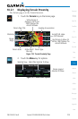
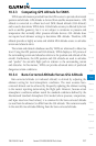
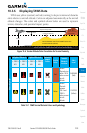
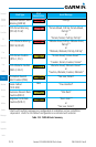
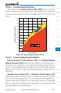
10.3.6 Displaying TAWS Data
TAWS uses yellow (caution) and red (warning) to depict terrain and obstacles
alerts relative to aircraft altitude. Colors are adjusted automatically as the aircraft
altitude changes. The colors and symbols shown below are used to represent
terrain, obstacles, and potential impact points.
Potential Impact Point
Unlighted Obstacle
Projected Flight Path
1000 ft
100 ft Threshold
Terrain more than 1000 ft below the aircraft altitude (Black)
Terrain between 100 ft and 1000 ft below the
aircraft altitude (Yellow)
Terrain above or
within 100 ft
below the aircraft
altitude (Red)
Figure 10-6 Terrain Altitude/Color Correlation for Terrain Proximity
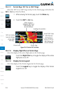
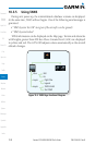
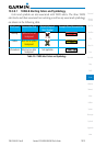
Unlighted Obstacle Lighted Obstacle Potential
Impact
Points
Terrain
Color
Terrain/
Obstacle
Location
Alert
Level
< 1000 ft
AGL
> 1000 ft
AGL
< 1000 ft
AGL
> 1000 ft
AGL
Obstacle Symbol
Red
Terrain/
Obstacle at or
within 100 ft
below current
aircraft
altitude
WARNING
(Red)
Yellow
Terrain/
Obstacle
between
100 ft and
1000 ft
below current
aircraft
altitude
CAUTION
(Yellow)
Table 10-1 TAWS Terrain/Obstacle Colors and Symbology