


10-10
Garmin GTN 625/635/650 Pilot’s Guide
190-01004-03 Rev. B
Foreword
Getting
Started
Xpdr Ctrl
Com/Nav
FPL
Direct-To
Proc
Wpt Info
Map
Traffic
Terrain
Weather
Nearest
Music
Utilities
System
Messages
Symbols
Appendix
Index
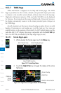
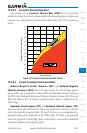
10.3.7 TAWS Page
TAWS information is displayed on the Map and Terrain pages. The TAWS
Page is specialized to show terrain, obstacle, and potential impact point data
in relation to the aircraft’s current altitude, without clutter from the basemap.
Flight plan information (airports, VORs, and other NAVAIDs) can be displayed
for reference. If an obstacle and the projected flight path of the aircraft intersect,
the display automatically zooms in to the closest potential point of impact on
the TAWS Page.
Aircraft orientation on this map is always heading up unless there is no valid
heading. If orientation is not heading up, it will be track up. Two views are
available relative to the position of the aircraft: the 360° default display and the
radar-like ARC (120°) display. Map range is adjustable with the In and Out keys
from 1 to 200 NM, as indicated by the map range rings (or arcs).
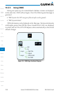
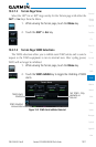
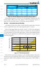
10.3.7.1 Terrain Page Layers
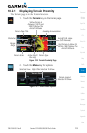
1. While viewing the Terrain page, touch the Menu key.
Select Terrain View
Select Displayed Layer
Select TAWS Function
Figure 10-7 Terrain Page Menu
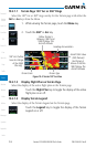
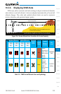
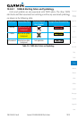
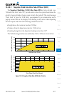
2. Touch the Flight Plan key to toggle the display of the active
flight plan.
Terrain Overlay
Flight Plan
TAWS-B Annunciation
Terrain
Legend
Obstacles
Figure 10-8 Flight Plan and Legend Shown On Terrain Page