


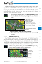

8-5190-01004-03 Rev. B
Garmin GTN 625/635/650 Pilot’s Guide
Foreword
Getting
Started
Xpdr Ctrl
Com/Nav
FPL
Direct-To
Proc
Wpt Info
Map
Traffic
Terrain
Weather
Nearest
Music
Utilities
System
Messages
Symbols
Appendix
Index
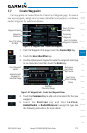
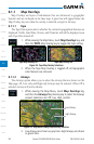
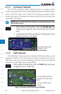
8.1.1.3 Terrain
The Terrain Data option selects whether Terrain Data is shown on the Map
page. Terrain and NEXRAD weather may not be displayed at the same time.
Selecting one will disable the other. A Terrain icon will indicate that the Terrain
overlay has been selected. Terrain overlay colors may or may not be shown
depending on the altitude of the aircraft.
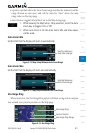
1. While viewing the Map Menu, touch Map Overlays key, and
then the Terrain Map Overlay key to toggle the view of Terrain
data.
Red Terrain - At or
Within 100 ft below
Aircraft Altitude
Yellow Terrain -
Between
100 ft and 1000 ft below
current aircraft altitude
Icon Shows Terrain Overlay
Is Active
Figure 8-6 Map Menu Terrain Map Overlay On Selection
2. The colors of the terrain are referenced to your aircraft
altitude.
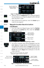
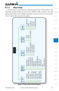
8.1.1.4 NEXRAD (Optional)
The NEXRAD menu option allows the display of NEXRAD weather
information overlayed on the Map page. Terrain and NEXRAD weather may not
be displayed at the same time. Selecting one will disable the other. NEXRAD
weather is an optional feature that requires the installation of a GDL 69/69A and
an XM Weather subscription. See the Weather section for more detail.
While viewing the Map Menu, touch the NEXRAD Map Overlay
key to toggle the view of NEXRAD weather data.
NEXRAD
Weather
NEXRAD
Product Age
Figure 8-7 Map Menu NEXRAD Map Overlay On Selection