


10-5190-01004-03 Rev. B
Garmin GTN 625/635/650 Pilot’s Guide
Foreword
Getting
Started
Xpdr Ctrl
Com/Nav
FPL
Direct-To
Proc
Wpt Info
Map
Traffic
Terrain
Weather
Nearest
Music
Utilities
System
Messages
Symbols
Appendix
Index
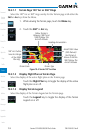
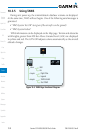
10.2.2 Terrain Limitations
Terrain Proximity displays terrain and obstructions relative to the altitude of the
aircraft. The displayed alerts are advisory in nature only. Individual obstructions
may be shown if available in the database. However, all obstructions may not
be available in the database and data may be inaccurate. Terrain information
should be used as an aid to situational awareness. Never use this information for
navigation or to maneuver to avoid obstacles.
Terrain Proximity uses terrain and obstacle information supplied by
government sources. The displayed information should never be understood as
being all-inclusive.
NOTE: The data contained in the Terrain Proximity databases comes from
government agencies. Garmin accurately processes and cross-validates the
data but cannot guarantee the accuracy and completeness of the data.