


11-8
Garmin GTN 625/635/650 Pilot’s Guide
190-01004-03 Rev. B
Foreword
Getting
Started
Xpdr Ctrl
Com/Nav
FPL
Direct-To
Proc
Wpt Info
Map
Traffic
Terrain
Weather
Nearest
Music
Utilities
System
Messages
Symbols
Appendix
Index
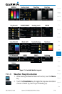
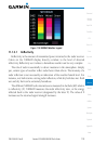
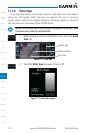
11.1.5 NEXRAD
WSR-88D, or NEXRAD (NEXt-generation RADar), is a network of 158 high-
resolution Doppler radar systems that are operated by the National Weather
Service (NWS). NEXRAD data provides centralized meteorological information
for the continental United States and selected overseas locations. The maximum
range of a single NEXRAD radar site is 250 NM. The NEXRAD network provides
important information about severe weather for air traffic safety.
NEXRAD data is not real-time. The lapsed time between collection, processing,
and dissemination of NEXRAD images can be significant and may not reflect
the current radar synopsis. Due to the inherent delays and the relative age of
the data, it should be used for long-range planning purposes only. Never use
NEXRAD data or any radar data to penetrate hazardous weather. Instead, use it
in an early-warning capacity of pre-departure and en route evaluation.
Composite data from all the NEXRAD radar sites in the United States is shown.
Canadian radar data provided by Environment Canada. This data is composed
of the maximum reflectivity from the individual radar sweeps. The display of the
information is color-coded to indicate the weather severity level.
NOTE: Due to similarities in color schemes, the display of Echo Tops cannot
be shown with Cloud Tops and NEXRAD.
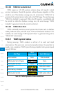
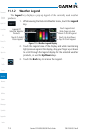
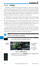
1. While viewing the Datalink Weather menu, touch the NEXRAD
key to step through the NEXRAD selections.
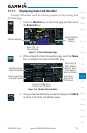
NEXRAD
Weather
Age Of Selected
Weather
Products
City Forecast -
Touch To Select
Time
Figure 11-7 NEXRAD Weather
2. Repeated touches to the NEXRAD key will toggle between
the Off, US, and Canada selections.