


8-18
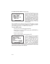
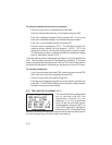
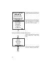
To calculate density altitude and true airspeed...
· Place the cursor on the indicated altitude (IAlt) field.
· Enter the indicated altitude from your altimeter and press ENT.
· Enter your calibrated airspeed (CAS) and press ENT. If you do not
know your calibrated airspeed, use indicated airspeed instead.
· Enter your current altimeter setting and press ENT.
· Enter the total air temperature (TAT). The GPS 95 will display the
resulting density altitude and true airspeed. (NOTE: TAT is the
temperature of the air including the heating effect caused by speed.
The temperature read on a standard outside air temperature gauge
found in most piston aircraft is TAT.)
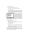
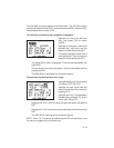
The winds aloft calculation determines the direction (true) and speed of the
wind. This calculation requires TAS and heading information. If you have
already calculated density altitude and TAS, the TAS value will be used for
the winds aloft calculation; otherwise you may enter the correct TAS value.
To calculate winds aloft...
· If you have not already calculated TAS: place the cursor over the TAS
field, enter the correct true airspeed and press ENT.
· Place the cursor over the heading (Hdg) field.
· Enter the current heading (magnetic) from your heading indicator and
press ENT. The GPS 95 will display the wind direction, speed, and the
head/tail wind you are encountering.
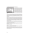
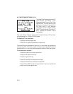
8.16 TRIP AND FUEL PLANNING (E6-B)
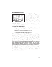
The Trip and Fuel Planning Page allows
you to calculate time and fuel
requirements between any two
waypoints or for any programmed
route. On the first cyclic field, you will
choose between waypoint (WPT) or
route (RTE) planning by highlighting
and pressing CLR. If route planning is
selected, you would then select the desired route number and the portion of
the route (a given leg or all of the route) to calculate for.