


8-4
8.3 SATELLITE SKYVIEW PAGE
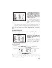
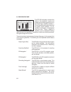
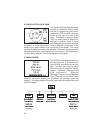
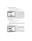
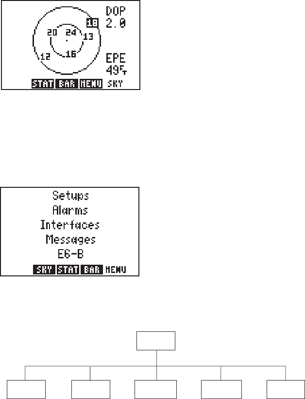
The Satellite Skyview Page shows the
azimuth and elevation of each visible
satellite in a graphic sky view format.
Additionally, DOP and EPE values are
shown on the right hand side of the
page. The display is always oriented
“north up” and is useful in determining
whether a satellite signal is being
blocked by part of the aircraft, buildings,
mountains, or other obstructions. Satellite elevation is indicated by the
distance (of a given satellite) from the center of the display. The center
represents directly overhead, or 90° elevation. The inner ring represents 45°
elevation and the outer ring is the horizon, or 0° elevation. If a satellite is not
currently being received, it will be highlighted on the display.
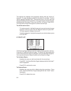
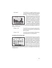
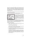
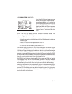
8.4 MENU PAGES
The GPS 95's menu pages allow you to
do setup functions to customize your
unit and E6-B calculations to plan your
flight. The Main Menu lets you select
from five functional categories: Setups,
Alarms, Interfaces, Messages and
E6-B calculations. Selecting
“Messages” lets you view the Message
Page. Selecting one of the other items
reveals a sub-menu allowing you to perform the functions under that
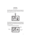
category. The diagram below shows the organization of the Main Menu and
sub-menu pages.
Density Alt / Winds
s
V
V
e
e
r
r
t
t
i
i
c
c
a
a
l N
l N
a
a
v
v
Sunrise / Sunset
Date / Time
Input / Output
Trip & Fuel Plannin
g
SUA Alarms
Beacon Receiver
O
peration Mode
T
T
r
r
a
a
c
c
k L
k L
o
o
g
g
A
A
udio / Display
Map Datum
U
U
nits / Heading
Setups
M
M
a
a
i
i
n
n
Menu
E6-B
Messages
Interfaces
Alarms
Arrival / CDI