


10-7
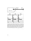
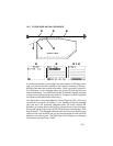
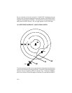
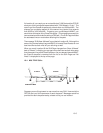
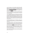
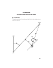
All the examples described in this section are based on real airspaces. If your
unit contains the Americas database, you may use the Simulator Mode to
duplicate these scenarios and observe how the unit would actually operate
when flying near an SUA. (Refer to Section 5.5 for more information on using
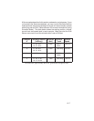
Simulator Mode.) The table below shows the starting position, altitude,
ground track and speed used in each example. Make sure that the SUA
alarms are turned on and the altitude buffer is set to 500 feet.
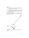
Example Starting
Position Altitude Ground Ground
# (lat/long) (feet) Track Speed
1 N 35° 43.5' 10,500 GOTO 100 KTS
W 91° 09.0' KBVX
2* N 36° 02.5' 10,500 269° Mag. 135 KTS
W 91° 25.0'
3 At KIXD airport 3,000 GOTO 125 KTS
KMKC
4 N 34° 11.45' 4,500 263° Mag. 90 KTS
W 115° 30.00'
*At location #3, approximately W 92° 40', ground track changes to 259°.