


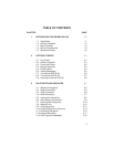
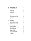
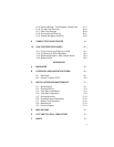
1-2
· Alarms: An alarm clock and timer allow the GPS 95 to watch the clock
for you. Arrival, CDI and special-use/controlled airspace alerts help
you safely navigate your aircraft.
· Interfaces: Interface with PC-based moving map programs using
NMEA 0183 output, with Differential GPS (DGPS) beacon receivers
using RTCM (SC-104 version 2.0) input, or with marine autopilots and
graphic plotters using NMEA 0180/0182/0183 outputs. An optional
PC kit is also available to download user waypoints and routes to your
PC for permanent record.
We encourage you to read this manual and experiment using the built-in
simulator. This will help you quickly master the many features of the GPS 95.
1.2 AVIATION DATABASE
The GPS 95 features a Jeppesen database providing direct access to either
Americas or International navigation information. When the GPS 95 is turned
on the display will show which database the unit contains. Information
contained in the database is as follows:
· Airports: Identifier, city/state, country, facility name, latitude, longitude,
elevation, and fuel services.
· VORs: Identifier, city/state, country, facility name, latitude, longitude,
frequency and co-located DME (or TACAN).
· NDBs: Identifier, city/state, country, facility name, latitude, longitude
and frequency.
· Intersections: Identifier, country, latitude and longitude.
· Communication Frequencies: ATIS, ground, tower, multicom and
unicom. (Multicom and unicom frequencies are grouped together
under a “unicom” designation.)
· Runways: Runway designations, length, surface, lighting (including
frequency for pilot-controlled lighting), and graphic runway configuration.
· Special-use and Controlled Airspaces: Alert, caution, danger,
MOA, restricted, training, warning and prohibited areas. Class B /CTA
and Class C / TMA airspaces.
The Americas Database covers North, Central and South America. The