


8-2
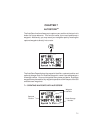
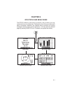
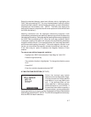
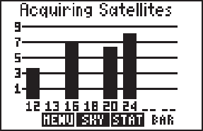
8.1 BAR GRAPH PAGE
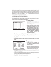
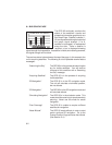
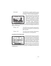
The GPS 95 continually monitors the
status of the satellites it tracks and
shows that information graphically on a
Bar Graph Page. Satellite numbers (1-
32) are represented along the bottom of
the graph; signal strength (1 to 9,
weakest to strongest) is represented
along the side. Once a satellite is
received, a bar is displayed showing
signal strength for that satellite. If a satellite is visible, but not being received,
the signal strength will be blank.
The receiver status is also shown at the top of the page. In this example, the
unit is acquiring satellites. The following is a list of possible receiver status
messages:
“Searching the Sky” The GPS 95 is in the process of searching the
sky for visible satellites. You will also be
informed of this condition with a “Searching
the Sky” message.
“Acquiring Satellites” The GPS 95 is in the process of acquiring
visible satellites.
“2D Navigation” The GPS 95 is in the 2D navigation mode.
The unit will calculate a horizontal position,
but not altitude.
“3D Navigation” The GPS 95 is in the 3D navigation mode and
will calculate altitude
“Simulating Navigation” The GPS 95 is in the simulator mode. This
mode should be used only for practice and trip
planning. Never use this mode for actual
navigation.
“Poor Coverage” The GPS 95 is unable to acquire sufficient
satellites for navigation.
“Need Altitude” The GPS 95 needs altitude in order to start
and/or continue 2D navigation. Go to the
Present Position Page and enter the altitude.
(See Section 5.4.)