


User’s manual maps + more
- 78 - Useful functions
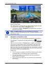
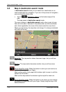
The smaller of the two areas indicates the distance you can still drive
from your current position and still reach the home address reliably on
the subsequent return trip.
Note: The radius of action for the return trip can be shown only if the
indicated home address is still reachable.
If no home address is specified, the current position will be taken as the
return address.
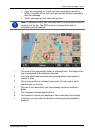
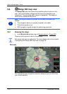
9.6.2 Configuring the Range 360 map view
1. In the NAVIGATION window tap on More functions > Settings > Map
display.
2. Use the Range 360 setting to define how you want to present the
range on the map:
► One way: Shows the maximum range.
► Reliable return: Shows the maximum range when the return trip
to the home address is considered.
► Both: Shows both ranges.
10 Useful functions
10.1 Route profiles
Route profiles define the characteristics and special aspects of the
different modes of transport which are to be taken into account when
calculating routes. For example a route profile for bicycles will exclude
motorways from the route calculation but will include roads which other
vehicles are not allowed to use. And different arrival times will be
calculated for a bicycle than for a motorcycle for example.
10.1.1 Route profile settings
A route profile is made up of several settings:
► Speed profile: Defines the mode of transport (e.g. Bicycle,
Pedestrian, Car, ...).
► Type of route: Defines the type of route which is to be calculated
(e.g. Short route, Fast route, ...).
► Consider traffic information: defines whether traffic messages are to
be considered when calculating the route
► Motorways, Ferries, Restricted areas: Defines whether these types
of road are allowed to be used.
► Use of toll roads: defines whether toll roads are allowed to be used
when calculating the route.