


User’s manual maps + more
- 56 - Navigation
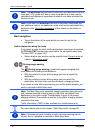
7.4.6 Calculating and displaying routes
It is possible to calculate and display a planned route on the map even
without GPS reception in order to get an impression of the journey.
The R
OUTES AND TRACKS window is open. The starting point and at
least one route point have been entered.
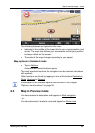
► Tap on Show route.
The map opens in Preview mode.
The starting point and the route points are marked by flags. The
distance and the estimated trip time is given for each leg of the
route.
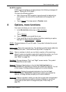
7.4.7 Simulating routes
It is also possible simply to simulate navigation on a planned route.
Note: GPS reception is not necessary for simulation.
If you have planned a multi-leg route, only the first leg will be simulated.
You have calculated and displayed a route.
1. Tap on Options > Simulation.
► If you have planned a route with only one route point and the
MyRoutes function is activated, you will be prompted to select
a route for the simulation.
The route will be recalculated for simulation purposes.
2. Tap on the button of the route on which you want to simulate the
navigation.
For more details about the MyRoutes function refer to the chapter
"MyRoutes" on page 57.
Stopping simulation
You can stop simulation at any time.
► Tap on (Back).
The ROUTES AND TRACKS window opens.