


There are other important Fishing Hotspot symbols that display information
only on your GPS unit. They are all accessed with the cursor and either the
Wpt or Find key. These symbols are usually (but not always) located near
the dam site, and they include:
Fishing Tips & Techniques: the Waypoint Information screen will
display an article covering topics ranging from lures to locations.
Tackle hints, types of cover and presentation methods are discussed by
season and species, covering the major species in this lake.
Lake Profile: the screen will display an overview of the lake itself,
including information on size, depth, shoreline, bottom composition,
water source, water quality and fish cover.
Fishery: the screen will display information on the major species pre-
sent, their numbers and sizes, management practices, forage species
and any special regulations.
Fishing Area Information: this symbol appears in scattered
locations around certain lakes. When this symbol is selected, the
Waypoint Information screen will display specific fishing tips for that area of
the lake.
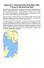
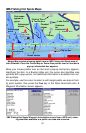
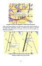
MapCreate lets you turn off the Master Map display of Map Category Op-
tions, such as depth, fishing areas, lake info, lake services, navigation in-
formation, and structure, but this does not change the detail in your IMS
Fishing Hot Spots map.
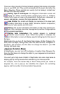
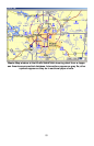
Jeppesen Aviation Maps
In MapCreate, you can turn off the display of aviation Map Category Op-
tions, but that does not change the detail in your Jeppesen and aeronauti-
cal databases.
You won't get a high level of detail in MapCreate, but some map items do
display pop-up tool-tip boxes when selected by your mouse pointer.
For example, move the Center Map or Zoom Area pointer just inside an
airspace line, and a pop-up box identifies the airport, the controlling
agency and the number of communication frequencies.
83