


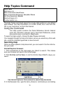
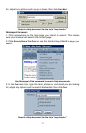


73
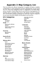
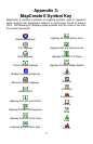
Appendix 2: Map Category List
This list contains the different categories of mapping information available
in MapCreate 6. These categories and their subcategories can be turned
off or on. Only those categories turned on (displayed in the Master Map)
will be included in Custom Map Files for your GPS unit. See Appendix 3 for
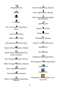
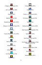
symbols used to represent these items. POI stands for Point of Interest.
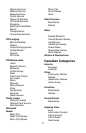
U.S. and Canadian category groupings are listed here. Specific categories
for your area may differ slightly, but the patterns will be similar.
U.S. Categories
Airports
Runways
Symbols
Cities
Community Names
Names
Subdivision Names
Urban Areas
Countries
Boundaries
Names
County/Parish
Boundaries
Highway Exits
Exits
Information Centers
Parking Areas
Picnic Areas
Rest Areas
Scenic Areas
Service Areas
Toll Plazas
Welcome Centers
Weigh Stations
Highways
US
International Minor
International Major
Interstate Symbols
Interstate
State
State Symbols
US Symbols
Landmarks
Buildings
Cemeteries
Fire Stations
Land Features
Libraries
Mines
Other
Schools
Shopping Center
Summits
Towers
Trail Names
Marine Navaids
Major
Minor
POI-All Others
Airports
Attractions
Auto Parts/Service
Banks/Financial
Bars/Nightclubs
Entertainment
Fishing/Hunting
Food Stores
Gasoline
Government