


6
jump through to cram a high-detail map into your GPS unit.
First of all, those CDs you just purchased contain a whole bunch of raw digi-
tal cartography data. There are several hundred files of digital mapping in-
formation containing lake shorelines, navigation aids, roads, rivers and all the
other information that goes into our high-detail maps.
It takes some fancy formatting to fit the whole world onto a few compact
discs. Your GPS unit can't read those raw files (called atlas files). Even if it
could, no GPS unit or MultiMedia Card (MMC) has enough memory to hold
that much information.
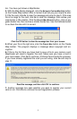
This is where MapCreate comes in. The program looks at all those raw
atlas files, shuffles the different types of information together, and then
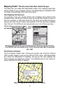
places them onto your computer screen. That's what we call the Master
Map, the main window in the MapCreate interface. By changing various
options in MapCreate, you can control how much geographic detail is dis-
played on-screen in the Master Map.
It's a pretty cool electronic map, but your GPS can't read it in this form,
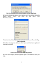
either. This is where you come in. You move around the Master Map and
locate the area or areas you want to make a detailed map of. Then, you
grab the computer mouse and draw a map border around the region you
want. (There are two or three fun ways to do this…we'll describe 'em in a
few minutes.)
Now, this map border isn't really a map yet — it just defines or outlines the
area you want to include in the final GPS-friendly map. If you wish, you can
save the boundary you have drawn as a Map Border File. MapCreate
uses a map border like an electronic shopping list. The program looks at
your border, grabs the appropriate raw atlas information, and then glues it
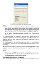
all together as a custom map. Now you can save this data as a Custom
Map File on an MMC (or SD card) and load it into your GPS unit. (If you
like, you can backup the Map File by copying it from the MMC card to your
computer's hard drive.)
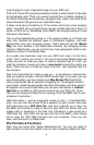
GPS information — such as waypoints, routes or trails — is handled differ-
ently. You can click the mouse to set a waypoint or plan a route, then save
that information as a GPS Data File. Just save it directly on or copy it to
the MMC and this file is ready to load into your GPS unit. When your unit
makes trails or waypoints in the field, that information is also saved as a
GPS Data File. Your GPS unit can save the file to the MMC, which allows
you to copy the GPS Data File back into your computer. Then you can
open, edit and save it in MapCreate.
File Formats & Functions
Well, now you know what makes MapCreate tick. You may be ready to
skip forward to where we explain how our text formatting makes the man-