


MapCreate can be used to save valuable travel or adventure data for a
later trip. This also makes it easy to exchange GPS data with friends using
Brunton Atlas GPS units.
ASCII Text File
This is a universal text file format compatible with word processors and
other software. MapCreate can exchange routes and waypoint lists with
other mapping programs by importing and exporting GPS information as
comma-delimited ASCII text files. ASCII (pronounced "ask-ee") uses the
*.txt file extension. You don't need to work with these files, unless you plan
to exchange routes and waypoints between MapCreate and other mapping
programs. If you want to create a text file manually, or if you need to manu-
ally edit a route or waypoint text file, this is the waypoint position format
MapCreate will export or import:
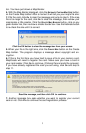
[latitude],[space][longitude],[space][waypoint name]
Each position is written in degree (decimal) format. For North latitudes, use
the latitude with no preceding symbol. For South latitudes, a minus sign
must precede the number, like this: –latitude.
For East longitudes, use the longitude with no preceding symbol. For West
longitudes, a minus sign must precede the number, like this:
–longitude.
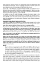
The first waypoint in the following example text file is N 36.06079846º, W
95.78354912º.
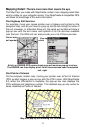
Latitude Longitude Waypoint Name
Comma and space
separate items.
11
36.060798, -95.783549, Church 1
36.060784, -95.761647, Turn North 2
First wpt
36.161831, -95.761529, Turn N-East On Hwy66 (3)
36.162581, -95.753760, Wpt 004*
36.169981, -95.751795, Wpt 005*
36.382616, -95.556565, Turn N-West 6
36.385315, -95.560847, Turn North 7
Last wpt
36.503465, -95.561081, Stop Turn East 8
In routes, sequence is important. 1st line is wpt 1, 2nd line is wpt 2 and so
Text files are saved in the C:\Program Files\LEI\MapCreate\Data folder. For
more information on how to use text files, see the Help file Command Ref-
erence topics "Export GPS Data," "Import Route" and "Import Waypoint
List."
GPS Data Manger (GDM) File
This is an older file format used by MapCreate 5 and MapCreate 4 to hold
navigation data (waypoints and such). MapCreate 6 can open these files,
making the program backward compatible with versions 5 and 4. The GDM
file extension is *.low. Although MapCreate 6 is designed to load and read