


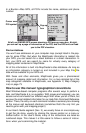
10
don't have to take a computer and cable with you to load a new map in the
field. If the unit is mounted in a vehicle, there is no need to dismount it and
carry it to a computer. The effective mapping memory capacity of your
GPS unit is restricted only by the capacity and number of memory cards
you want to carry with you, up to the five-card limit. This is a handy feature
for long journeys or for users who can't lug a laptop computer along.
Four factors control Map File size: 1. map detail level option settings, 2. the
number of map feature categories turned on, 3. the amount of developed or
naturally occurring features in the area and 4. the amount of territory, that is,
the number of square miles or acres in the area.
Detail Level Options can be set to high or medium. The higher the level
of detail, the bigger the file size.
There are dozens of Map Category Options that you can turn off and on.
They include natural features — such as rivers — and man-made items
such as roads, businesses or other points of interest. The more catego-
ries and subcategories turned on, the bigger the file size.
The amount of development in an area is something you can't control.
For example, one square mile of city streets will make a larger file than one
square mile of wilderness with a few hiking trails.
The amount of territory you include in a map is a major factor. The more
square miles or acres you include, the bigger the file size.
The lessons in the manual were written using MapCreate's default set-
tings, with high detail and all categories turned on. If your first maps don't
fit your MMC or SD card, refer to the Help file's Command Reference sec-
tion for more detailed instructions on controlling file size.
GPS Data File
This file format contains all the GPS navigation information (waypoints, event
marker icons, routes and trails) used by your GPS unit and MapCreate. The file
extension is *.usr (for User file). By default, MapCreate first saves a GPS Data
File to the C:\Program Files\LEI\MapCreate\Data folder, but if you prefer you
can save it direct to your MMC card. If you save elsewhere, MapCreate re-
members that location the next time you save. Since GPS data files are not
encrypted, it does not matter how you move .usr files around. As with other
Windows-based files, you can freely drag and drop these files back and forth
from the hard drive to any MMC.
You can open and make changes in a GPS Data File once it has been cre-
ated. The contents can include any combination of waypoints, routes, trails
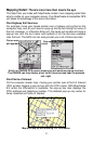
and event marker icons. The information shows up graphically on the Mas-
ter Map as symbols with names. The same information is also available as
text in a list window, such as the Waypoint List window.
Your GPS unit saves field-collected GPS information in the same format so