


69
Appendix 1: MapCreate Command List
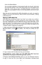
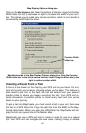
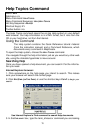
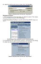
Complete documentation on all MapCreate commands is available in the
program's Help File. To access Help and its Command Reference section,
press F1. An example entry from the Command Reference (for the Help Com-
mand) appears at the end of this command list.
About MapCreate
Arrange Icons
Arrange Windows
Auto Arrange Windows
Card Registry
Cascade Windows
Center Map
Close All Windows
Clear Map Borders
Create Custom Map
Create Icons
Create Route
Create Route From Trail
Create Waypoints
Delete
Delete Icon
Delete Map Border
Delete Route
Delete Route Waypoint
Delete Trail
Delete Waypoint
Draw Borders Around Route
Draw Corridor Map Borders
Draw Map Borders
Edit Icon
Edit Route
Edit Route Waypoint
Edit Waypoint
Estimate Map Size
Exit
Export Route
Export Waypoint List
Help Topics
Import Map Borders From File
Import Route
Import Waypoint List
Insert Icon
Insert Route
Insert Route Waypoints
Insert Waypoint
New GPS Data File
New Map Border File
Open GPS Data File
Open Map
Open Map Border File
Print GPS Data
Print Map
Printer Setup
Restore Original Settings
Save All
Save GPS Data File
Save GPS Data File As
Save Map Border File
Save Map Border File As
Tile Windows Horizontally
Tile Windows Vertically
View Icon List
View Map Category Options
View Map Display Options
Data Display Options
Detail Level Used
GPS Data
Default Symbol
Map Borders Options
Draw block boundaries
Draw corridor hot spots
Corridor Width
Position Format Options
Zoom Options
Zoom Range Units
Map Zoom Change
View Route List
View Route Waypoint List
View Status bar
View Toolbar
View Trail List
View Waypoint List
Zoom In / Zoom Out