


88
build highly detailed highway routes. These "high res" routes are fun to
use, but they have some drawbacks. They require placing a route waypoint
at practically every curve in the road. This takes a relatively large number
of waypoints for the distance traveled. A large set of waypoints close to-
gether can give your Custom Map a cluttered look. If the route is very long,
it takes more time for you to make it in MapCreate. And, finally, GPS units
compatible with MapCreate versions 5 and 6 can hold 100 routes, but each
route can contain only 100 waypoints.
So, take a long cross-country trip on winding roads and you can use up
100 waypoints before you reach your journey's end. This means you will
need to break up the trip into multiple routes. That's usually not a problem,
since most travelers don't prefer to run all day and night without stopping
for food, fuel or rest.
On the other hand, "low res" routes take less time to prepare and are
plenty accurate to get you there. This type of route — with a relatively
small number of waypoints per mile — is well-suited to map screen naviga-
tion. You can cover a longer distance for the amount of waypoints you use.
"Low res" routes also tend to reduce the clutter on your Custom Map.
A good technique for "low res" routes is to set most of your waypoints
where you make major direction changes, or where the destination is im-
portant for one reason or another. Here are two examples:
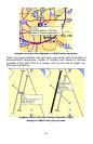
Let's say you are heading straight north on a state highway, but need to
turn right onto a county road to reach a recreation area. Set a route way-
point at or just a little before the highway intersection. Setting the waypoint
a short distance before your turn is useful (especially at highway speeds) if
you need some warning to change lanes or slow down for the turn. (You
can even rename that route waypoint "turn" or "turn right.")
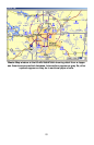
Now let's say you are traveling in a generally straight line. You don't need
to set a waypoint for a turn, but you want to stop in a certain city along the
way for food or fuel. Set a route waypoint at the city limits or downtown,
and your Brunton Atlas can tell you how many miles to town and how long
it will take to get there.
If you limit the number of waypoints you make, your compass rose will still
work fine for those major changes in direction, but it won't match the twists
and curves of the pavement as closely as a "high resolution" route would.
For example, you could be traveling toward a destination to the south, but
following a highway curve around a mountain. As you take the curve to
your right, your car will actually be pointing west as you follow the pave-
ment. However, the compass rose is accurately pointing to that next
southern waypoint, now 90 degrees off to your left. If you were depending
only on the compass rose at that moment, it might look like you were off