


Appendix C: C-MAP Chart Card Features C-1
C-MAP Chart Card
Features
Appendix C: C-MAP Chart Card Features
TheC_MAP chartcardsdisplaycartographicfeatureswhich arederived from
a library of symbols. The library includes a setof 16 x 16 pixel bitmaps which
provide realistically shaped icons for many chart objects. However, these
complexiconscan overlapand clutterthe displayat some scales,so itpossible
for the userto select smaller, simple icons. Some chart objectsare represented
by text; in such cases conventional abbreviated text is used, for example, M –
mud, R – rock, Wk – wreck
Thechartplottersetupmenu providesthesub-menuCUSTOMISE CHART,which
lets you determine how chart features are displayed. You can set the icon
display of many features to custom; you then use the CUSTOM soft key to
switch the customized icons off/on. The factory default for the CUSTOM
options is on.
The chart features controlled from the Customize Chart menu are grouped as
detailed below, some groups are sub-divided into categories
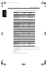
Menu Option Chart Features
CHART TEXT Names
CHART BOUNDARIES Chart Boundaries
SPOT SOUNDINGS Spot Soundings
DEPTH SHADING LIMIT Reference Depth
DEPTH CONTOURS Depths (Bathymetric Lines)
Depth Labels
DEPTH CONTOUR DIS-
PLAY
Depth Contour
Range
NAV MARKS Lights:
Light;
Light moire’ effect;
Light float;
Light vessel
Buoys and Beacons:
Buoy, cardinal
Buoy, installation
Buoy, isolated danger
Buoy, lateral
Buoy, safe water
Buoy, special purpose
Buoy, generic
Beacon, cardinal
Beacon, isolated dan-
ger
Beacon, lateral
Beacon, safe water
Beacon, special pur-
pose
Beacon, generic
Signals
Anchor
Cairn
Chain/Wire
Fog signal
Radar reflector
Top mark
Nav aid, generic
Extended nav- aid,
generic
Radar station
Radar transponder bea-
con
Radio station
LIGHT SECTORS Light Sectors
81186_3.book Page 1 Thursday, August 22, 2002 8:23 AM