


Appendix C: C-MAP Chart Card Features C-3
C-MAP Chart Card
Features
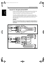
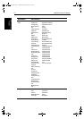
LAND FEATURES Natural Features
Coastline
Dune
Hill
Land elevation
Land region
Land
Salt pan
Slope topline
Tree
Vegetation area
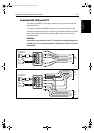
Natural Features -
Rivers
Canal
Canal bank
Rapids
River
River bank
Waterfall
Lake
Lake shore
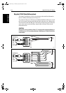
Cultural Features
Airport area
Built-up area
Railway
Road crossing
Road part
Runway
Sloping ground
Square
Cable, overhead
Fence
Pipeline, overhead
Pylon
Telepheric
Tunnel entrance
Building, religious
Building, single
Cemetery
Fortified Structure
Siloway route part
Tank
Chimney
Dish aerial
Flagstaff/flagpole
Flarestack
Mast
Monument
Radar dome plane land-
ing area
Tower
Windmill
Windmotor
ICON DISPLAY Complex (detailed) object/Simple object
Menu Option Chart Features
81186_3.book Page 3 Thursday, August 22, 2002 8:23 AM