


Chapter 2: Getting Started & Adjusting the Display 2-23
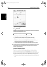
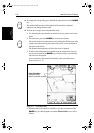
Typical Chart
Scenarios
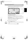
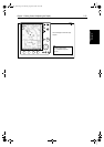
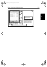
• If Plotter Mode is Off, the chart scale remains unchanged, indicating
the smallest chart scale is displayed.
Note: If Plotter Mode is Off and the cursor is homed to the vessel (see
Using FIND SHIP onpage 2-20),if thevessel moves outside an area of
available cartography, the chart will automatically re-scale tothe next
range with cartography.
• IfPlotter Mode isOn,the scale isdecreasedand the message NO CHART
DATA is displayed. The vessel, waypoints, routes and tracklines are dis-
played without cartography.
Thechartinformationisrestoredwhenyoureturntoa chartscaleforwhichthe
information is available.
➤ Tozoomoutto asmaller-scale(lessdetailed)chart,simplypresstheupperpart
of the RANGE key as many times as required.
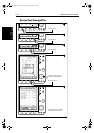
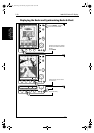
2.6 Typical Chart Scenarios
Thefollowingillustrationsprovideoperatingguidelinesfortypicalnavigation
scenarios. Thesescenarios canbeused asa trainingguide; they showyou how
to perform a particular operation and they introduce many of the chartplotter
functions.
Eachscenarioindicatesthekey pressesrequiredto performparticular tasks.A
typical chartplotter screen image is shown for each task.
The scenarios assume you have read the previous sections of this chapter and
that you are familiar with the Operating Controls. Full operating details for
each function are provided in Chapter 5 and Chapter 6.
Operating guidelines are provided for the following scenarios:
• Working with Waypoints
Place a Waypoint
Goto a Waypoint
• Make and Follow a Route
CreateaRoute
Follow a Route
• Review the Passage Plan
View Route Information
Change the SOG, Hours and ETA.
• Displaying the Radar Image and Synchronizing Radar & Chart
Changing the Full-Screen Mode & Selecting Half-Screen Windows
Radar and Chart Synchronization (Find Ship)
Cursor Echo
RANGE
81186_3.book Page 23 Thursday, August 22, 2002 8:23 AM