


Chapter 1: Overview 1-15
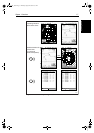
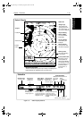
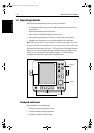
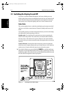
Chartplotter
Functions
Chartplotter
Functions
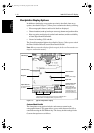
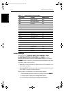
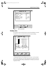
ON: Chart text, chart boundaries, depth contours, navigation marks
and land features.
OFF: Caution and routing data.
CUSTOM: Spot sounding, light sectors, marine features.
Note: The factory default for the CUSTOM settings is ON.
Icons are displayed in detail, depth shading limit is 10 m and depth contour
display is 0-100 m.
A complete list of chart features is given in Appendix C.
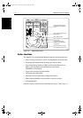
Chartplotter Functions
The Chartplotter includes the following functions:
• Display C-MAP NT C-Card chart information including Ports and Tides
(if available)
• View chart information (if available) for the Nearest Port
• Place, Move, Erase and Edit a Waypoint
• Goto Waypoint or Cursor
• Create, Save, Name, Edit and Follow a Route
• Review Route and Waypoint Lists
• Display vessel’s track; Save and Name the Track for re-call to screen
• SmartRoute to make a track into a route
• Measure Chart Distances and Bearings on-screen
• Set Up Alarms and Timers
• Man OverBoard (MOB) to navigate back to a missing person or object
• Differential GPS set up page
Operation of these functions is described in Chapter 5 and Chapter 6.
81186_3.book Page 15 Thursday, August 22, 2002 8:23 AM