


COMAND navigation system (real-time traffic)
143
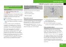
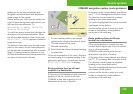
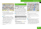
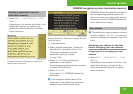
1
Blocked route section
2
Current vehicle position; the triangle
indicates the vehicle’s direction of travel
3
Information about the blocked route
section
i
Blocked route section 1 is always
highlighted in red/white. The information
about blocked route section 3 shows
which section of the route is blocked and
the length of the blocked section.
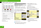
X
Starting route calculation: Select
Start, see also (Y page 123).
X
Deleting blockage: Select Navi £
Route £ Detour £ Delete.
X
Select Back.
COMAND navigation system (real-
time traffic)
Introduction
A RDS-TMC (Radio Data System-Traffic
Message Channel) radio transmitter
broadcasts traffic reports COMAND can
receive and incorporate into the navigation
system. Traffic report messages and map
symbols can then be viewed in the COMAND
display. Events displayed are those within
receivable range of the vehicle’s location.
i
Actual road and traffic conditions may be
different from the received messages.
Real-time traffic notifications in the
map
COMAND can display certain traffic events in
the map. The notifications are shown at the
map scales from 0.05 mi (50 m) to 500 mi
(500 km).
X
Set the map scale: Turn ymz until the
desired map scale is set.
Turning clockwise enlarges the map,
turning counterclockwise reduces it.
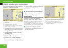
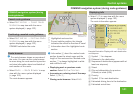
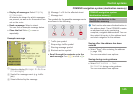
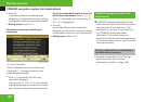
Example illustration: Display for a traffic jam on the
route
1
Symbol for event on the route
2
Marker symbols for the affected route
section
3
Current vehicle position and direction of
travel
4
Map scale
i
COMAND marks the entire route section
affected with appropriate symbols 2,
independently of its actual length on the
route section. Symbols 2 are shown in the
direction of travel on the left or right of the
route.Thus, they also indicate which side of
the roadway is affected by the event.
Control systems
Z