


87
Detailed Operation
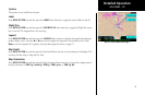
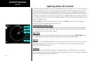
Chart View (CHART) Function (Optional)
The optional MX20 Chart View feature provides the capability to view Jeppesen Sanderson Inc. electronic
charts. Two basic types of charts can be viewed: Approach charts and airport surface charts.
Approach charts can be manually loaded and overlaid on the moving map during flight, while airport surface
charts are automatically overlaid while on the ground. Both types of charts are also viewable from the Chart
View Function in a chart manual fashion. Approach charts may also be loaded automatically when installed
with a GNS 480-series GPS receiver.
The electronic chart data is generated from the standard Jeppesen CD ROM product, which is distributed and
updated by Jeppesen on a two-week schedule. The in-flight data resides on the pilot removable front-loading
data card and is updated by the pilot using a home PC-based data loader.
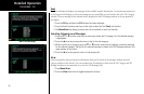
Overview
• Charts are viewed either as a dynamic overlay on the Custom/IFR Map, or as a static page through the
dedicated Chart View Function (“Chart” on the function menu).
• When viewed as a dynamic overlay on the Custom/IFR Map, the chart will be properly geo-referenced
with respect to the base map. Orientation (track up, north up, etc.), zoom scale, and aircraft position
will all be properly presented relative to the chart data, using the standard map controls.
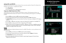
• When viewed under the Chart View Function, more selection options are available for locating a specific
chart among the charts in the database, and the chart is displayed similar to a standard chart manual
(north up) with no position overlay.
• A given approach chart must be “loaded” for map overlay usage by first selecting the airport of interest,
then selecting the individual chart for that airport. Approach charts can be loaded from either the
Custom/IFR Map, the Chart View Function, or the Autoload function from a GNS 480-series GPS
receiver.
• Pressing the INFO key while a chart is loaded or being viewed will bring up the header, profile and
minimums associated with the chart.
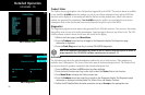
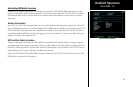
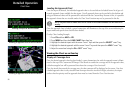
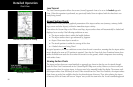
Chart View
ChartView as viewed on the Custom Map Page