


112
Detailed Operation
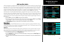
Display Latitude/Longitude Lines
Use this option to choose to display or not display Lat/Lon lines on the map displays.
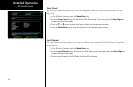
Initial En Route Zoom and Initial Ground Zoom Transition Speed
A zoom scale auto-transition point is supported that helps to reduce the pilot workload by automating the
selection of the zoom scale based on the phase of flight. The two transitions are:
• Ground-to-Air mode (Takeoff)
• Air-to-Ground mode (Landing)
When the aircraft transitions from Ground-to-Air, the zoom scale is automatically set to a user selected “en
route” zoom scale. When the aircraft transitions from Air-to-Ground, the zoom scale is automatically set to a
user selected “Ground” zoom scale. The transition point is based on a user selected En Route/Ground Transi-
tion Speed and is based on GPS ground speed.
The Auto-Transition feature allows for optimal close-in viewing while on the ground and optimal long range
viewing while in flight, without the user having to make manual zoom scale adjustments while in the takeoff
and landing phases of flight. The Zoom scale is shown in the lower left corner of the display.
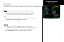
The En Route and Ground zoom scales and the transition point are adjusted under the SYS Function.
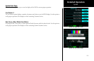
“En Route/Ground Transition Speed” – 10-100 kts
“Initial En Route Zoom Scale” – Auto, 0.25 – 250 nm
“Initial Ground Zoom Scale” – 0.25 – 5 nm
The recommended settings for the initial zoom scales are Auto for the en route mode and 0.5 nm for the
ground mode.
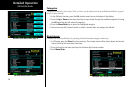
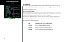
1. Press FN until you see the SYS function key.
2. Press the SYS function key.
3. With the “NAV” selection highlighted press MENU/ENTER.
4. Press the NEXT PAGE Menu Item key.
5. Press the Menu Item keys as needed to select the settings. Press MENU/ENTER to save your settings.
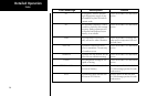
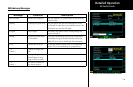
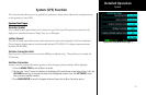
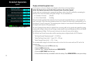
System
System Nav Setup Menu Items (Page 2)