


26
Detailed Operation
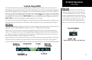
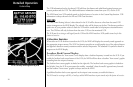
Custom Map Menu Option Page 3
The third option page of the Custom Map function lets you select options for the choices of Low Airways,
High Airways, Water, Roads, and political boundaries. The last option selection takes you to the next page of
options.
Low Airways
The Low Airways option allows you to control the display of Low Airways. Pressing the MENU ITEM key next
to Low Airways toggles between either the display of the airway and label, airway alone, or no display of Low
Airways.
High Airways
The High Airways option allows you to control the display of High Airways. Pressing the MENU ITEM key
next to High Airways toggles between either the display of the airway and label, airway alone, or no display of
High Airways.
Water
The Water option allows you to control the display of rivers and lakes. Pressing the MENU ITEM key next to
Waters toggles between either the display or no display of the bodies of water.
Roads
The Roads option allows you to control the display of interstate and state highways. Pressing the MENU ITEM
key next to Roads toggles between either the display or no display of the road features.
Boundaries
The Boundaries option allows you to select the display of political boundaries on the Map displays.
Press the Next Page MENU ITEM key to display the next page of menu items.
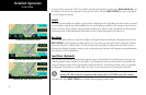
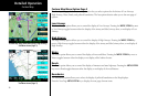
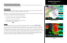
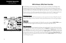
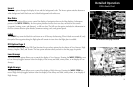
Custom Map
Custom Map page with Low Airways, High Airways,
and Menu Items (Page 3)
Custom Map page with Water, Roads, Boundaries,
and Menu Items (Page 3)