


70
Detailed Operation
Temporary Flight Restrictions (TFRs)
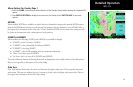
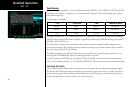
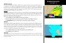
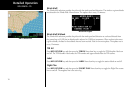
Temporary Flight Restrictions (TFRs) indicate areas where flight restrictions have been imposed. They are
depicted as areas with reddish-brown outlines. The area may also contain the TFR identifier label. The TFR
identifier label includes the TFR number and upper altitude. Press the TFR Lbl Menu Item key to toggle the
TFR Identifier Labels on and off. TFRs are drawn on the FIS page when provided by the FIS sensor and can not
be enabled or disabled. TFR text information is described on page 81.
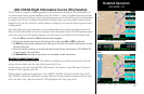
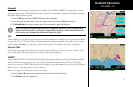
NEXRAD Description
WSR-88D weather surveillance radar or NEXRAD (NEXt generation RADar) is a Doppler radar system that has
greatly improved the detection of meteorological events such as thunderstorms, tornadoes, and hurricanes.
An extensive network of NEXRAD stations provides almost complete radar coverage of the continental United
States, Alaska, and Hawaii. The unobstructed range of each NEXRAD is 124 nautical miles.
NEXRAD Abnormalities
There are possible abnormalities regarding displayed NEXRAD images. Some, but not all, causes of abnormal
displayed information include:
• Ground Clutter
• Strobes and spurious radar data
• Sun strobes, when the radar antenna points directly at the sun
• Military aircraft deploy metallic dust which can cause alterations in radar scans
• Interference from buildings or mountains, which may cause shadows
NEXRAD Limitations
Certain limitations exist regarding the NEXRAD radar displays. Some, but not all, are listed for the user’s awareness:
• NEXRAD base reflectivity does not provide sufficient information to determine cloud layers or
precipitation characteristics (hail vs. rain, etc).
• NEXRAD base reflectivity is sampled at the minimum antenna elevation angle. An individual NEXRAD
site cannot depict high altitude storms at close ranges, and has no information about storms directly
over the site.
• The resolution of displayed NEXRAD data is 2 kilometers. Therefore, when zoomed in on the display,
each square block is 2 kilometers. The intensity level reflected by the square will be the highest level
sampled within the 2 kilometer square area.
GDL 69/69A - FIS
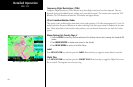
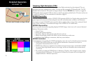
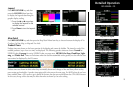
NEXRAD Color Legend
TFR Outline with TFR Number and Upper Altitude