


35
Detailed Operation
Split Screen (SPLIT) Function
The Split Screen capability allows you to display up to two enabled functions side by side. Press the MENU
ITEM key next to the desired map to highlight the selection. When two functions are displayed, you must first
deselect a highlighted selection before selecting another function. Review the Limitations section in the front of
this guide for the limitations that apply to the data displayed on the moving map.
A vertical profile may be optionally selected to be shown on the lower portion of the display. The profile view
is only available when there is no TAWS sensor enabled and the Terrain function is based on the internal
terrain database. The profile display is always oriented in the Track-Up mode, where the depicted terrain is a
cross-section of the terrain just below the aircraft’s current track. Obstructions are not shown on the profile
display and the aircraft current altitude is provided next to the ownship symbol. The altitude scale adjusts
automatically with the aircraft altitude. The zoom scale and map orientation are displayed in the upper right
corner of the profile display.
When two functions are displayed, the left and right quarter of each function is not displayed, leaving the
center half of the original display. The image is not compressed from full width to half width.
Functions with an ownship symbol are displayed in Track-Up map orientation and do not include the track
line and compass rose.
Press the Main Menu Item key to go to the next page of the Menu.
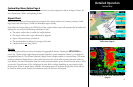
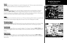
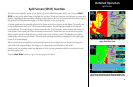
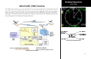
Split Screen
Split Screen showing Custom Map and Flight Plan
pages with Menu Items
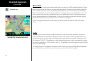
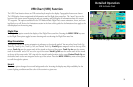
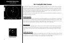
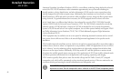
Split Screen showing Custom Map and Flight Plan
pages along with the Vertical Profile & Menu Items