


7
Getting Started
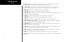
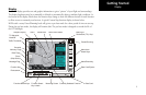
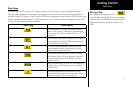
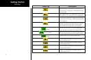
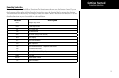
Data Flags
Data flags appear on the left side of the display to notify you when there is a loss of reported information.
The data usually displayed, such as lightning or nearby terrain, may still exist, but may not be displayed for
technical reasons. For instance, when the amber TRAF data flag appears it means that the MX20 is not receiving
Traffic information from the sensor. So, traffic may exist in your vicinity, but will not be displayed on the MX20.
All flags are amber unless otherwise indicated.
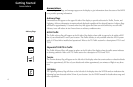
Data Flag Description
No valid position information is available from the
source. Do not expect a valid position representation
on the maps. The Ownship symbol will have an “X”
through it.
No valid route (flight plan) is available from the exter-
nal navigation source. Route (flight plan) information
will not be shown on the maps.
No valid altitude information is available from the
external source. Altitude related functions will not
operate, such as terrain awareness.
No traffic information is received from the optional
traffic sensor. Traffic will not be displayed. Your posi-
tion information may not be broadcast in ADS-B
capable systems.
The GPS receiver in the GDL 90 UAT is not reporting
a valid position. ADS-B broadcast will not include a
position report.
No valid lightning detection information is being
received from the optional Stormscope sensor. Strike
and cell information will not be displayed.
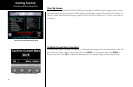
Message Flag
The Message flag will appear on the
lower left side of the display when a new message
is posted. Go to the Message function to view the
information about the operation or status of the
MX20.
Data Flags