


55
Detailed Operation
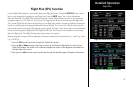
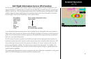
Flight Plan (FPL) Function
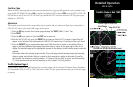
Use the Flight Plan function to view details about your flight plan route. Press the UP/DOWN arrow “smart”
keys to step through the waypoints in your flight plan. Press the INFO “smart” key to view information
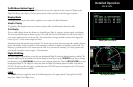
about the waypoint. The Flight Plan Function shows the Current Flight Plan that is active in the connected
navigation source (i.e. GPS receiver). The Current To Waypoint box shows the current leg of the flight plan.
The Current Flight Plan box shows all of the legs of your flight plan with the current leg indicated in magenta.
Listed are each leg with the bearing and distance between the legs. The Current Nav Data box shows the air-
craft current position in latitude and longitude, ground speed, and track. In the lower right corner information
for the current waypoint is displayed in the Waypoint Info box. The Nearest Center frequency is shown just
above the flight plan. The Flight Plan function does not have any options.
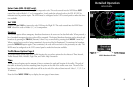
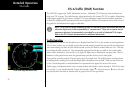
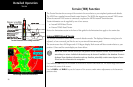
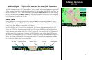
Runway diagrams of airports will be displayed in the same orientation as the main map (i.e., North Up, Track
Up, or DTK Up).
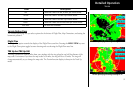
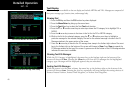
1. Press the FPL function smart key to reach the Flight Plan function.
2. Press the Up or Down function smart keys to move up and down the flight plan list in the Current
Flight Plan window. The details for the selected waypoint are shown in the Waypoint Info window on
the right side of the screen.
3. Each press the Info function smart key will step through the available pages of Waypoint Information.
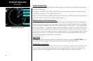
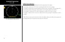
Flight Plan
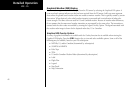
Flight Plan Information (UAO selected)
Flight Plan Information (PDX selected)