


32
Detailed Operation
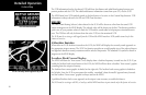
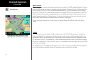
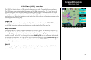
Airport Chart
Airport surface charts provide a graphical presentation of the airport surface area (runways, taxiways, build-
ings, towers and other objects), within the immediate airport vicinity.
From either the Custom Map or the IFR en route Map, airport surface charts will automatically be loaded and
displayed as an overlay if the following conditions are met:
• The airport surface chart is within the loaded database
• The airport surface chart is geo-referenced by Jeppesen
• Airport Chart menu layer is turned on
• The aircraft position is within the coverage of the chart
• A loaded chart is not being “flown”
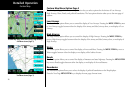
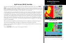
Load Chart
Once the airport is selected, the individual approach chart to be overlaid can be loaded from a list of geo-ref-
erenced approach charts available for that airport. Not all approach charts can be overlaid in this fashion and
only geo-referenced charts will be presented for selection from the Custom Map. Because of this, it is possible
that approach charts that are viewable under the Chart View Function may not be presented in this list.
NOTE: The pilot must be aware that not all charts in the loaded database can be used as an
overlay. When enabled, a chart may be automatically loaded if installed with a GNS 480-series
GPS receiver. See the System Function to enable this feature.
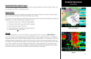
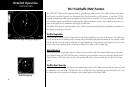
IFR En Route Chart