


73
Detailed Operation
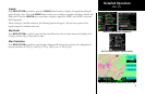
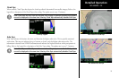
Cloud Tops
When enabled, Cloud Tops data depicts the cloud top altitude determined from satellite imagery. Refer to the
legend for a description of the Cloud Tops color coding. The update rate is every 15 minutes.
Note: Cloud Tops and Echo Tops use the same color scaling to represent altitude. Both products
can not be displayed at the same time. Selecting Cloud Tops automatically disables Echo Tops.
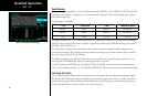
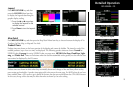
Echo Tops
Echo Tops indicate the location, elevation, and direction the highest radar echo. This is typically associated
with storms. This may not indicate the top of a storm or clouds, only the highest radar return echo. The
information is derived from NEXRAD information and indicates the highest altitude at which precipitation is
falling. Refer to the Legend for a description of the Echo Tops coding. The update rate is every 7.5 minutes.
Note: Cloud Tops and Echo Tops use the same color scaling to represent altitude. Both products
can not be displayed at the same time. Selecting Echo Tops automatically disables Cloud Tops.
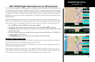
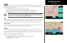
GDL 69/69A FIS Cloud Tops
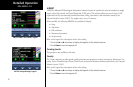
GDL 69/69A FIS Echo Tops
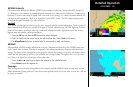
GDL 69/69A - FIS
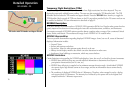
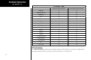
Cloud Top Legend
Echo Tops Legend