


63
Detailed Operation
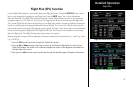
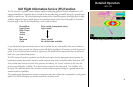
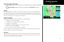
Menu Options for Overlay Page 1
1. Press the OVRL function key to allow selection of the Overlay choices when viewing the Graphical WX
option.
2. Press MENU/ENTER to display menu items for the Overlay. Press NEXT PAGE to see more
options.
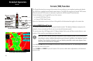
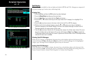
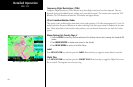
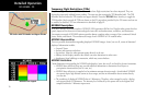
METARs
When enabled, METARs are available as colored circles or diamonds at airports that provide METAR reports.
Press the METARs Menu Item key to cycle through the options of circular, diamond, or no METARs. Refer to
the Legend for a description of the color code. US and Canadian METARS use the same color coding and will
be shown at the same time with a subscription to both products.
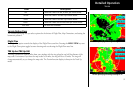
SIGMETs & AIRMETs
When enabled, the following SIGMETs and AIRMETs are available for display:
• “SIGMETs” are for Convective SIGMETs
• “T AIRMET” is for Surface/Aloft Turbulence AIRMETs
• “Z AIRMET” is for Icing AIRMET
• “S AIRMET” is for an IFR condition, such as a mountain obstruction
• “Other” is for other types of AIRMETs
• “No Warn. Area” is to turn off all SIGMETs and AIRMETs
These are collectively known as Warning Boxes and are displayed as color coded outlines of the affected area.
Refer to the Legend for a description of the color coding.
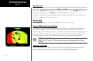
Echo Tops
Echo Tops indicate the location, elevation, and direction the highest radar echo. This is typically associated
with storms. This may not indicate the top of a storm or clouds, only the highest radar return echo. Refer to
the Legend for a description of the Echo Tops coding.
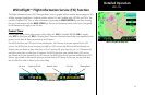
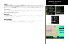
WSI - FIS
WSI FIS Graphic Weather Overlay Menu Items (Page1)