


82 96/96C Owner’s Manual
MaIn paGeS >
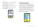
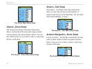
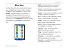
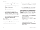
The Highway Page
When you are navigating a route, the Highway Page
can guide you to the destination using data elds and
a graphic highway. Up to four user-selectable data
elds show information such as speed, distance,or
time to next point on the route. The list of data to
show and the method of selection is the same as for
the HSI/Pointer Page and is explained in detail on
page 67.
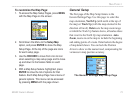
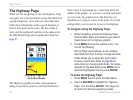
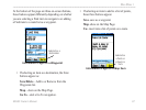
Highway Page with
an Active Route
The Highway graphic provides visual guidance,
taking you point by point to your nal destination.
Your course is represented by a center line down the
middle of the graphic. As you move toward each point
on your route, the graphic shows the direction you
should move to stay on course to the point. Five scale
settings allow you to zoom in or out on the highway.
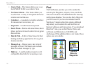
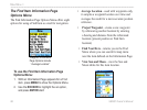
To navigate using the Highway Page:
1. While navigating, access the Highway Page
from the Main Menu and observe your path of
travel shown on the highway graphic.
2. Press MENU to show the options menu. You
can do the following:
Set Up Page Layout allows you to congure
data elds from four to three. Change the Data
Fields allows you to select the type of data
to show in each eld. Refer to page 66 for
instructions on changing data elds. To restore
defaults for the data elds press MENU with a
data eld highlighted and the press ENTER.
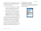
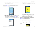
To show the Highway Page:
1. Press MENU twice to show the Main Menu.
2. Use the ROCKER to highlight the “Highway
Page” icon and press ENTER. This page can
be shown for all three operating modes.