


56 96/96C Owner’s Manual
BaSIc operatIon >
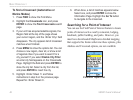
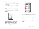
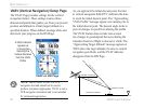
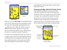
VNAV (Vertical Navigation) Setup Page
The VNAV Page provides settings for the vertical
navigation feature. These settings create a three-
dimensional prole that guides you from your present
position and altitude to a nal (target) altitude at a
specied location. When dened, message alerts and
data track your progress on the HSI Page.
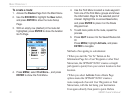
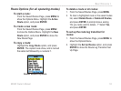
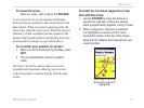
VNAV on HSI Page
A VNAV indicator
appears as
a moving bar
depicting the
Vertical Deviation
from the VNAV
Prole.
NOTE: The GPSMAP 96/96C is a VFR
navigation tool and should not be used to
perform instrument approaches. VNAV is only a
VFR navigation instrument and is not intended
for instrument approaches.
As you approach the initial descent point, the time
to vertical navigation eld (ETV) indicates the time
to reach the initial descent point. The “Approaching
VNAV Prole” message appears one minute prior to
the initial descent point. The descent angle locks to
prevent changes in speed from altering the prole.
The VNAV feature does not take into account
any changes in groundspeed that occur during the
transition from level flight to descent or climb. The
“Approaching Target Altitude” message appears at
500 ft above the target altitude, the time to vertical
navigation goes blank, and the VNAV indicator
disappears from the HSI Page.
VNAV PROFILE
GLIDE RATIO TO TARGET
DISTANCE TO TARGET
DISTANCE TO PROFILE
TARGET ALTITUDE
AIRPORT