


96/96C Owner’s Manual 63
MaIn paGeS >
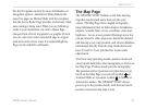
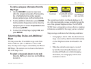
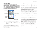
To retrieve airspace information from the
Map Page:
1. Use the ROCKER to select an open area
within the airspace’s boundary. The boundary
line is highlighted and a window appears
showing airspace type and oor/ceiling limits.
2. To show additional information, press ENTER.
Communication frequencies can be shown by
highlighting the on-screen Frequencies button
and pressing ENTER.
3. To return the to Map Page, highlight OK, and
press ENTER.
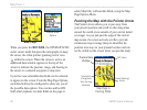
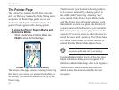
Selecting Map Scales and Additional
Maps
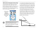
The map screen has 28 available range scales from
20 ft. to 800 nm. (20 ft. to 800 mi or 5 m to 1200
km). The map zoom range is controlled by the IN and
OUT keys. The current scale is shown at the bottom
left of the map screen.
To select a map scale (zoom in and out):
Press the OUT key to zoom out and the IN key
to zoom in.
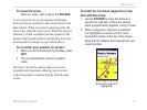
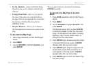
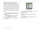
Overzoom
No additional
data available
Using MapSource
downloaded detailed
mapping data
Using the built-in
basemaps
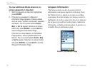
The system has a built-in worldwide database to 20
mi, with more detailed coverage available through the
use of the optional MapSource data. The GPSMAP
96/96C shows cartography as long as there is mapping
information available for the range you have selected.
Map coverage conforms to the following conditions:
• Cartography is shown when the selected zoom
range is covered by either the internal basemap
or other MapSource data downloaded to the
unit.
• When the selected zoom range is covered
by both the internal bundled database and
downloaded MapSource detailed mapping
information, the cartography with the best
resolution is shown.