


96/96C Owner’s Manual 65
MaIn paGeS >
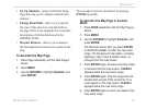
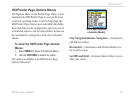
• Set Up Obstacles—jumps to Obstacle Setup
Page allowing you to congure obstacle alert
settings.
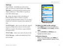
•
Change Data Fields—allows you to specify
the type of data shown in each data eld on
the page. Refer to the Appendix for a complete
descriptions of all data elds used in the
GPSMAP 96/96C.
•
Measure Distance—allows you to measure
the bearing/distance between two points on the
map.
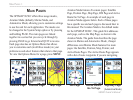
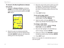
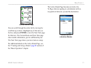
To declutter the Map Page:
1. Press Page repeatedly until the Map Page is
shown.
2. Press MENU.
3. Use the ROCKER to highlight Declutter, and
press ENTER.
You can adjust the level of declutter by pressing
ENTER repeatedly.
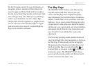
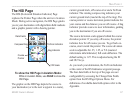
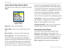
To declutter the Map Page in Aviation
Mode:
1. Press PAGE repeatedly until the Map Page is
shown.
2. Press MENU.
3. Use the ROCKER to highlight Declutter, and
press ENTER.
The rst level shown after you press ENTER
is identied by Clear -1 under the map zoom
range. The background map detail—including
highways, cities, rivers & smaller lakes—is
removed from the map screen.
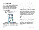
4. Press ENTER again. Airspace boundary detail
is removed from the map screen. CLEAR-2
appears below the map zoom range.
5. Press ENTER again. Only the waypoints and
navaids that are part of the current Go To or
route appear on the map screen. CLEAR-3
appears below the map zoom range.
6. Press ENTER again to return ALL detail to the
map zoom range.