


92 96/96C Owner’s Manual
MaIn Menu >
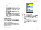
3. The next prompt asks you, “Select the ending
point for the saved track.” Use the Panning
Arrow to identify a point on the track that you
want as the End Point, and press ENTER. A
Saving Track message appears followed by
the Saved Track Page.
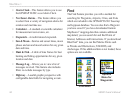
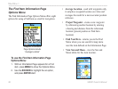
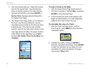
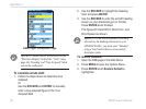
4. The Saved Track Page allows you to: Rename
the track, view the track distance, view the
calculated area encircled by the track (an area
is dened even if the track is open ended),
specify a color for the track when shown on the
map page (Show On Map). On-screen buttons
at the bottom of the page allow you to Save
the track OK, Delete, View it on the Map, and
TracBack.
Saved Track Page
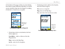
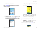
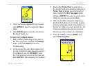
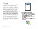
To view a Track on the Map:
1. With the Saved Tracks Page for the track or
the Track Log shown, highlight Map, and press
ENTER to show the Map Page.
2. A map showing the entire track appears with
Begin and End markers. Any User Waypoints
added to the Track is shown as well.
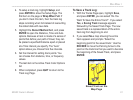
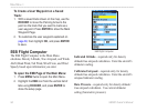
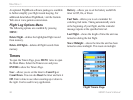
To calculate the area of a Track:
1. With the Track Log Page shown, and the
Track Log On, press MENU to show the Area
Calculation option.
2. Highlight the option, and press ENTER to
show the calculation Start Page. Press ENTER
to start the calculation as you begin to move
and dene the area’s boundaries. The page
now shows a Stop button.