


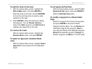

96/96C Owner’s Manual 59
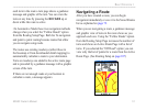
MaIn paGeS >
See the Navigation section for more information on
navigation options. Automotive Mode features the
same ve pages as Marine Mode with the exception
that the Active Route Page provides instructions when
auto-routing is being used. When you are following
roads to your destination, the Active Route Page
changes from a list of waypoints to a graphic of each
turn on your route with a turn detail page to support
each turn on the active route. An optional Highway
Page can be enabled in all modes.
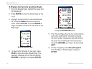
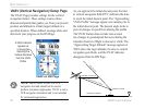
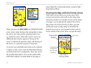
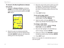
The Map Page
The GPSMAP 96/96C features a real-time moving
map that can do much more than just plot your
course. The Map Page shows digital cartography
(map information) that includes airspace boundaries,
airports, navaids, lakes, rivers, coastlines, cities and
highways. An on-screen pointer (Panning) arrow lets
you pan ahead to other map areas, determine distance
and bearing to any map position, and retrieve database
information directly from the map. Dedicated zoom
keys (IN and OUT) are provided for instant scale
adjustments.
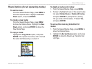
Two basic map operating modes, position mode and
cursor mode, determine what cartography is shown on
the Map Page. Position mode pans the cartography.
The position marker (position icon) that shows your
travel on the Map Page is an aircraft symbol in
Aviation Mode or a position symbol in Marine or
Automotive modes. The GPSMAP 96/96C always
powers up in the position mode, with the last known
location centered on the map screen.