


44 96/96C Owner’s Manual
BaSIc operatIon >
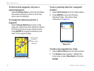
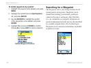
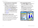
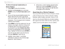
To use the Aviation Go To Page Options:
1. With the airport shown on the page, press
MENU to show the Options Menu.
2. Find More and Find Near Here take you to
the Find Menu. Show on Map shows the
airport on the map, Project Waypoint allows
you to project a new waypoint from that
location (see page 34), Set Proximity allows
you to set a proximity alarm for this location
(see page 36), and Add To Route allows to
place the airport in a route you are creating
(see page 22).
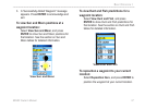
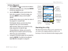
Searching for a Marine Point
The Find Marine Point feature allows you to search
for the marine items, such as marinas, navaids,
services, wrecks and obstructions. If using BlueChart
®
detailed marine chart data, the Tide Station feature
allows you to view tide predictions for locations
contained in the mapping data.
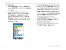
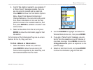
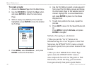
To nd a Tide Prediction Station
1. Press DIRECT TO
D
when in Automotive or
Marine mode to show the Find Menu.
2. Select the Marine Points icon, then press
ENTER to show the sub-icon(s) for marine
items supported by the basemap and
downloaded detailed marine charts.
3. Use the ROCKER to highlight and select the
Tide Station icon, then press ENTER.