


96/96C Owner’s Manual 7
BaSIc operatIon >
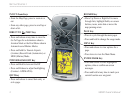
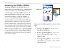
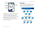
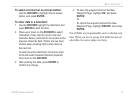
Satellite Page
Signal Strength
Bars
Satellite Array
“Sky View”
Current
Location
GPS Accuracy
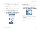
Press MENU to view options for Simulator, WAAS,
Track Up/North Up, Multicolor screen, and New
Location to use the Map Page to establish your
approximate location. Once the receiver has collected
information from and is xed on at least three
satellites, the unit is “Ready to Navigate” and you can
advance to the Map Page.
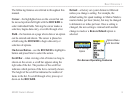
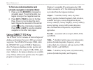
Status Bar
At the top of each page, a Status Bar provides the
current status for several unit features that are not
otherwise noticeable when operational.
Battery
Power
Auxiliary
Power
Backlight
On
Alarm Set
USB
Connected
System Symbols
Acquiring
Satellites
3-D
Navigation
2-D
Navigation
Simulating
Navigation
Satellite Status Symbols
Automotive
Mode
Aviation
Mode
Marine
Mode
Navigation Mode Symbols