


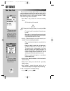


REFERENCE
You may use your present
position as the starting or
ending waypoint for trip
and fuel planning by leav-
ing the corresponding field
blank.
Once you have entered
the desired waypoints,
speed and other data, the
planning values will be dis-
played at the bottom of the
trip and fuel planning page.
87
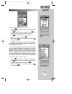
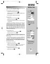
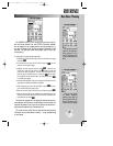
TRIP & FUEL PLANNING
The GPSMAP 195’s trip and fuel planning submenu lets you
plan and review distance, fuel, and ETE/ETA information between
any two waypoints; your present position and a stored waypoint; or
any part of a stored route. Sunrise and sunset information is also
provided. Two planning modes are available: point-to-point and
route planning.
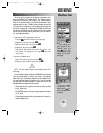
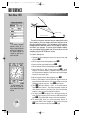
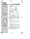
To use the point-to-point planning mode:
1. Highlight the ‘Trip & Fuel Planning’ option from the main menu page
and press
T
.
2. If the plan field is not set to ‘Point-To-Point’, press the
O
key and
select it from the options page.
3. Highlight the first waypoint field and press
T
. Press the left
arrow key to clear the field, and use the
R
keypad to enter the
name of the starting waypoint. You may leave the waypoint field
blank to use your present position, or press the
O
key to select
the waypoint from the waypoint list or the map display. Press
T
to confirm the waypoint.
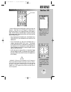
4. Move the field highlight to the second waypoint field and follow the
steps above to select the destination waypoint.
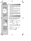
5. Enter a speed for your trip in the speed field, or press
O
to select
your current SPD for the speed value.
6. Enter an hourly fuel flow (if desired) in the fuel field, and press
T
.
7. Enter the date and time of your departure (the default date and time
will be the current date and time in UTC or local time, whichever you
have selected) and press
T
.
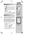
The bottom of the page will now display the desired track and dis-
tance between the two points; the estimated time enroute and fuel
required; the date and time of your arrival; and the sunrise and sun-
set times at the destination for the date of arrival.
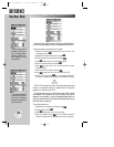
The route planning mode lets you calculate the same planning
information for any route stored in memory— in leg, cumulative leg
or route totals.
Main Menu: Planning
gps 195 manual C 7/1/99 4:49 PM Page 87