


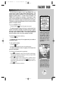
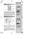
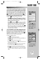
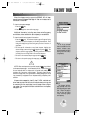

Pressing
©©
displays
the GOTO window, from
which you may select any
airport or navaid in the
Jeppesen database, or any
user waypoint you’ve
entered in memory.
The GOTO options page
lets you start a TracBack™
route or activate a stored
route to navigate.
21
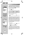
USING THE GOTO KEY
GPS is all about using positions called waypoints and navigating
to them using the receiver’s navigation guidance and map displays.
Now that you’ve seen how the status page can be used to monitor
satellite acquisition and the position and map pages can be used to
observe your present position, it’s time to explore the navigation fea-
tures of the GPSMAP 195— starting with the GOTO function. The
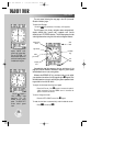
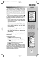
G
key, located on the left side of the keypad below the
P
key,
is the primary tool used to select a destination waypoint or a route to
navigate. The
G
key can be used in three main ways:
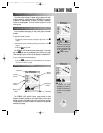
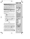
• Pressing
G
once displays a GOTO window from which you
may select any airport or navaid in the database, or any user way-
point in memory. When the destination is an airport, it may be
selected by identifier, facility name or city.
• Pressing
G
followed by the
O
key provides a list of GOTO
options that lets you start a TracBack™ route, select a published
approach for an airport, or select a stored route to navigate.
• After panning to a location on the map display, pressing
G
allows you to graphically select an on-screen waypoint, navaid or
cursor position as your destination.
For this simulated trip, we will select a nearby airport and fly
directly to that location. If you don’t recall the identifiers of any near-
by airports, return to the nearest airports page discussed on the pre-
ceding page and select your destination directly from the list (by
highlighting the desired waypoint first, then pressing
G
).
Otherwise, we’ll enter the identifier using the keypad.
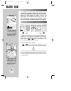
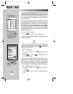
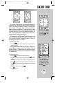
To select the destination airport:
1. Press
G
. The GOTO window will appear.
2. Highlight the waypoint identifier field by pressing the DOWN arrow
on the
R
keypad.
3. Press
T
to begin entering the airport identifier.
4. Use the UP and DOWN arrow on the
R
keypad to enter the first
character of the airport identifier.
5. Use the RIGHT arrow of the
R
keypad to move to the next charac-
ter. (If you make a mistake, back up with the LEFT arrow.)
6. Repeat steps 4 and 5 until the airport identifier has been selected.
7. Press
T
to accept the selected airport. The top of the map page
should now indicate the bearing and distance to the selected
airport.
TAKEOFF TOUR
gps 195 manual C 7/1/99 4:48 PM Page 21