


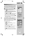
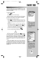
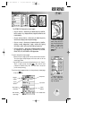
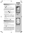

The GPSMAP 195 features four airport pages:
• Airport location— allows entry of desired airport by identifier,
facility name or city; displays latitude, longitude, elevation; and
fuel availability.
• Airport communication— allows entry of desired airport by
identifier and displays radio frequencies/usage.
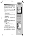
• Airport runway— allows entry of desired airport by identifier;
displays runway designations, length, surface and lighting
information, and/or pilot-controlled lighting frequencies.
• Airport approach— allows entry of desired airport by identifi-
er; displays final course segment of published ILS, localizer,
RNAV, GPS, VOR, VOR/DME or NDB approaches.
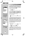
To scroll through the airport pages:
1. Select the airport category and enter the desired airport identifier.
The airport page initially displayed will be the same as the last
airport page viewed.
2. Use the LEFT arrow to move the field highlight to the ‘Loc?’, ‘Comm?’,
‘Rwy?’ or ‘Appr?’ prompt and press
T
. (Only three of these
prompts are available at any time. The fourth item is the screen
you’re currently viewing.)
To exit the airport pages and return to the previously viewed page:
1. Press the
Q
key.
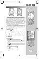
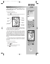
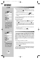
REFERENCE
The airport runway page
shows runway data and a
map of the area around the
airport. To zoom in/out
and see more detail for the
airport area, use the
AA
key.
To scroll through the var-
ious airport pages select
‘Loc?’, ‘Comm?’, ‘Rwy?’ or
‘Appr?’, as desired.
29
AIRPORT INFORMATION
Airport
Identifier
City Location
Facility Name
Waypoint
Category
Airport Position
Coordinates
Airport
Elevation
Available Fuels
Other Available
Airport Pages
WW
KEY
gps 195 manual C 7/1/99 4:48 PM Page 29