


30
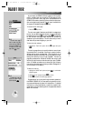
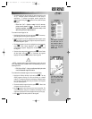
Use the
RR
keypad to
scroll through the list of fre-
quencies. As you progress
through the list, the scroll
bar on the right margin
shows which portion of the
list is currently being dis-
played.
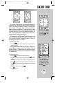
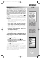
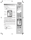
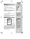
The airport location page
shows the facility name,
city, position coordinates,
field elevation and avail-
able fuels for the selected
airport.
The GPSMAP 195’s airport location page displays the latitude,
longitude and elevation of the selected airport, as well as fuel
availability. From the airport location page, you can enter a desired
airport by identifier, facility name or city as described on page 28.
The following descriptions and abbreviations are used on the airport
location page:
Elevation— Field elevation in feet or meters
Position— Airport location in the position format you have
currently selected from the setup page (e.g.,
latitude/longitude or UTM/UPS)
Fuel— Lists the types of fuel available on the airport:
• AV— AVGAS: 80-87 octane, 100 LL, 100-130 octane
• JET— Jet A, Jet A-1 or Jet A+
• MO— MOGAS: 87 octane unleaded
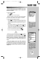
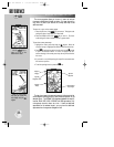
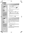
The airport communication page displays radio frequencies and
their usage for the selected airport, and allows entry of a desired
airport by identifier only (see page 28). The following frequencies are
displayed if available:
• ATIS • Pre-Taxi
• Clearance • Ground
• Tower • Unicom
• Multicom • Other
• Departure • Approach
• Arrival • Class B
• TMA • CTA
• Class C • TRSA
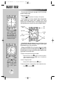
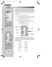
Airport
Identifier
Other Available
Airport Pages
Frequency
Waypoint
Category
Frequency
Type
Scroll Bar
REFERENCE
AIRPORT INFORMATION (cont.)
WW
KEY
gps 195 manual C 7/1/99 4:48 PM Page 30