


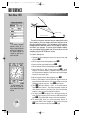

REFERENCE
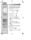
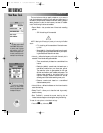
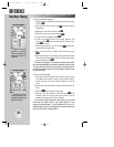
The vertical navigation
submenu allows you to
define a target altitude and
guide you on a descent to it.
The default settings are
intended to guide you to
pattern altitudes.
A VNAV indicator (hori-
zontal bar) will guide you
as you descend to the target
altitude.
84
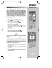
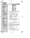
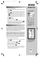
VERTICAL NAVIGATION
The vertical navigation submenu lets you create a VNAV profile
which guides you from your present position and altitude to a final
altitude at a specified location. Once the descent profile is defined,
message alerts and additional data on the HSI page will keep you
informed of your progress. To use the vertical navigation feature,
your ground speed must be greater than 35 knots and you must be
navigating using the GOTO feature or a route.
To create a VNAV profile:
1. Highlight the ‘Vertical Navigation’ option from the main menu page
and press
T
.
2. With the target altitude field highlighted, press
T
.
3. Enter the desired target altitude and press
T
.
4. With the altitude reference field highlighted, press
T
.
5. Select ‘Above Wpt’ or ‘MSL’ as desired and press
T
. ‘Above
waypoint’ will use the altitude of a destination airport as stored in
the internal Jeppesen database. ‘MSL’ lets you set a specific target
altitude (for any waypoint type).
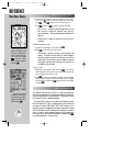
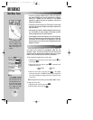
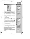
6. With the waypoint distance field highlighted, press
T
.
7. Enter an offset distance from the destination waypoint where the
target altitude should be reached. If the target altitude occurs at the
destination waypoint, enter zero. Press
T
when finished.
8. Press
T
and select ‘Before’ or ‘After’ for the offset distance.
Press
T
when finished. This setting designates whether the
offset distance defines a point before you reach the destination
waypoint or after you reach the destination waypoint.
9. For routes, press
T
to display a list of all waypoints along the
route. Select the waypoint you wish to use as a VNAV reference and
press
T
. (The default VNAV reference is the final destination.)
10. The default VNAV profile is a 400 foot-per-minute descent. To
change the VNAV profile, highlight the VNAV profile field, press
T
, enter a new descent rate and press
T
again.
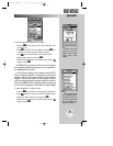
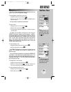
V
N
A
V
P
R
O
F
IL
E
G
L
ID
E
R
A
T
IO
T
O
T
A
R
G
E
T
DISTANCE TO TARGET
DISTANCE TO PROFILE
TARGET ALTITUDE
AIRPORT
Main Menu: VNAV
gps 195 manual C 7/1/99 4:49 PM Page 84