


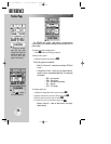

REFERENCE
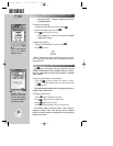
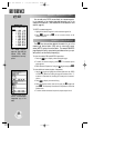
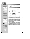
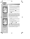
When the satellite signals
are first received , the sig-
nal strength bars are hol-
low, indicating the data
from these satellites is still
being processed.
Once the data is
processed, the signal
strength bars are filled in.
At this point, the
GPSMAP 195 can use the
satellites to determine its
position.
46
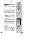
GOTO OPTIONS PAGE (cont.)
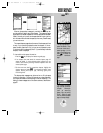
• Start TracBack?— allows you to create and start navigation
of a TracBack route back to the oldest track log point in
memory. (See pages 80-81 for more on using the TracBack
function.)
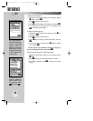
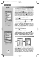
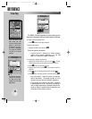
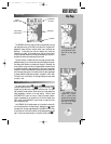
The GPSMAP 195’s status page provides a visual reference of
various receiver functions, including current satellite coverage,
receiver operating mode, battery strength and current receiver
accuracy. The status information will give you an idea of what the
receiver is doing at any given moment.
The sky view and signal strength bars give you an indication of
what satellites are in view and whether or not they are being received.
The signal strength is shown on a bar graph for each satellite, with
the satellite number below. When a satellite is in view but not
received, the signal strength bar will not be shown and the sky view
indicator will not be highlighted.
The sky view shows a bird’s-eye view of the position of each
satellite relative to the receiver’s last known position. The outer
circle represents the horizon, the inner circle 45º above the horizon,
and the center point a position directly overhead. Use the sky view
to determine if there are obstructions shading your reception of
GPS signals.
Battery
Indicator
Sky View
Estimated Position
Error
Signal Strength
Bars
Battery Icon
STATUS PAGE
Status Page
gps 195 manual C 7/1/99 4:48 PM Page 46