


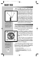
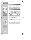
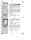
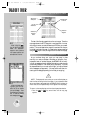

NEAREST WAYPOINTS PAGE
To display the nine near-
est airports, press the
˜˜
key. If the nearest list shows
navaids, airspaces, etc.;
press
˜˜
again to return
to the nearest airport list.
By pressing the
©©
key,
followed by
††
, the high-
lighted airport instantly
becomes your destination
waypoint.
20
Now that you have a feel for how the cursor works, it’s time to
move on and see how the GPSMAP 195 would look in the air. To help
you practice using the map page and other features, let’s use the
GOTO function to fly to an airport stored in the receiver’s memory.
From this, you’ll learn what to expect when you’re out flying with
your new GPS receiver.
Suppose you experienced an emergency during your trip and need-
ed to find a place to land. Better yet, you just want to stop for a break
at a nearby airport or top off the tanks. A list of the nine nearest air-
ports within 200 miles of your present position is just a keystroke
away! Instantly, you can select an airport from the list and designate
it as your destination waypoint. Or, you can review all the available
Jeppesen data for that particular airport. Let’s take a look at the clos-
est airports in your area.
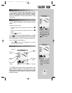
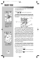
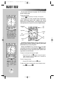
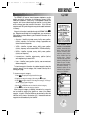
To view the nine nearest airports:
1. Press the
N
key to display the nearest waypoints page.
A list of the nine nearest airports appears, along with the bearing
and distance to each one.
NOTE: If for any reason the nearest waypoints page does not show airports,
but instead lists nearest airspaces (which we’ll cover in just a moment), VORs,
NDBs, intersections or user waypoints; just press the
N
key a second time
to return to the nearest airport list.
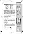
To GOTO a nearest airport:
1. Use the UP or DOWN arrows on the
R
keypad to highlight the
desired airport.
2. Press the
G
key, followed by
T
, to designate the airport as
your destination waypoint.
Now you can use the map or navigation pages to guide you to your
destination airport. Oftentimes, you may want more information
about an airport, like how long the runways are or if fuel is available.
From the nearest waypoints page you can review the Jeppesen data
for any listed airport or navaid, using the waypoint definition page(s).
To view the Jeppesen data for a nearest airport:
1. Use the UP or DOWN arrows on the
R
keypad to highlight the
desired airport.
2. Press the
T
key to view the waypoint definition page(s) for that
airport.
TAKEOFF TOUR
?
gps 195 manual C 7/1/99 4:48 PM Page 20