


APPENDIX F
104
GLOSSARY OF NAVIGATION TERMS
Bearing (BRG)—The compass direction from your
position to a destination waypoint.
Course Made Good (CMG)—The bearing from the
‘active from’ waypoint (your starting point when using
GOTO) to your present position.
Course To Steer (CTS)— The recommended direction
to steer in order to reduce cross track error and stay on
course. Provides the most efficient heading to get back
to the desired track and proceed along your route.
Crosstrack Error (XTK)—The distance you are off a
desired course in either direction, left or right.
Desired Track (DTK)—The compass course between
the ‘from’ and ‘to’ waypoints.
Distance To Active (Destination) Waypoint—
Distance from present position to the destination
waypoint in a GOTO or the next waypoint in a route.
Estimated Time of Arrival (ETA)—The estimated
time you will reach your destination waypoint, based on
current ground speed and track.
Estimated Time Enroute (ETE)—The time it will take
to reach the destination waypoint, from present position,
based on current ground speed and track.
Estimated Time To VNAV (ETV)— Prior to reaching
the initial descent point, ETV indicates the time it will
take to reach the initial descent point. After passing the
initial descent point, ETV indicates the time to reach the
target altitude following the designated vertical naviga-
tion parameters.
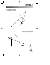
Glide Ratio (GR)— The ratio of horizontal distance
travelled to vertical distance travelled. For example, a
‘6:1’ glide ratio indicates a 1000’ vertical descent for
every 6000’ horizontal distance travelled.
Glide Ratio To Target (GRT)— The glide ratio
required to descend from present position and altitude to
the target altitude at the location specified on the vertical
navigation submenu.
Grid—A coordinate system that projects the earth on a
flat surface, with position measurements based on
northing and easting distances from square grid zones.
Ground Speed—The velocity you are travelling relative
to a ground position.
Ground Track (TRK)— see Track
Latitude—A north/south measurement of position per-
pendicular to the earth’s polar axis.
Longitude—An east/west measurement of position in
relation to the Prime Meridian, an imaginary circle that
passes through the north and south poles.
Position—An exact, unique location based on a
geographic coordinate system.
Track (TRK)—The direction of movement relative to a
ground position.
Turn Angle To Waypoint (TRN)— The difference
between Bearing (BRG) and Track (TRK). ‘L’ indicates
you should turn left, ‘R’ indicates you should turn right.
The degrees indicate the angle you are off course.
Universal Transverse Mercator/Universal Polar
Stereographic- (UTM/UPS)— A grid coordinate
system that projects global sections onto a flat surface to
measure position in specific zones.
Velocity Made Good (VMG)—The speed you are
closing in on a destination along a desired course.
Vertical Speed To Target (VST)— The speed at which
you are descending to the target altitude. A VST higher
or lower than specified on the vertical navigation sub-
menu indicates you are descending too fast or too slow.
gps 195 manual C 7/1/99 4:49 PM Page 104